The Walker's Haute Route: Ultimate Guide
Follow the footsteps of our team from Chamonix to Zermatt on the Haute Route: first-hand experience, difficulty, itinerary options and practical tips and more.

Quick links
Haute Route at a Glance
This guide is informed by first-hand experience on the trail. Tilen, a member of our team, hiked the full Walker's Haute Route in August 2024. He completed all 14 stages of the classic route with an additional night at Hotel Weisshorn — covering the full Chamonix-to-Zermatt traverse over two weeks.
Tilen's diverse hiking background includes:
30 days on the Slovenian Mountain Trail
multi-day treks in the Dolomites
and extensive day hiking across the Alps.
His observations, recommendations, and hard-won lessons from the trail are woven throughout this guide as pull-quotes, and he answers the most common questions hikers ask in the Q&A section at the end.

Route Map
What Is the Walker's Haute Route?
The word "haute" is French for "high" — and the route earns it. The Walker's Haute Route rarely descends to valley level. Most stages are spent above 2,000 m, with the trail skirting beneath 4,000 m peaks for the majority of its length, dipping into valleys only to reach each night's accommodation before climbing back up the next morning.

The "Walker's" distinguishes it from two other routes sharing the same corridor. The Classic Haute Route — first completed in 1860 by the British Alpine Club as a summer mountaineering route — crosses the same Chamonix to Zermatt line but via high glaciers, requiring crampons, rope, and technical experience. The Ski Haute Route (the same glaciated line in winter) is widely considered the most prestigious ski touring route in the world. The Walker's Haute Route is the hiking equivalent: same epic corridor, no technical mountaineering equipment, but demanding enough to be rated the hardest of the major Alpine long-distance trails.
What separates haute route hiking from routes like the Tour du Mont Blanc is its character. The TMB is more established, more serviced, and more sociable. The Haute Route is wilder, less crowded, higher, and more committed — it rewards the extra effort with a rawness the TMB's popular circuit cannot match. For a detailed comparison of how the two routes stack up, see our side-by-side breakdown of the two trails.
The route is entirely self-guided friendly. No permits are required, trail marking is consistent, and the accommodation infrastructure — while more challenging to book than the TMB — is well-established. It does not require a guide. What it requires is preparation.
If you'd prefer us to handle the logistics, see our Switzerland hiking tours — the Haute Route is one of our most popular self-guided packages.

Where Does It Go?
The Haute Route runs roughly 200 km from west to east — or more precisely, from southwest to northeast — in three broadly distinct geographic phases.
French Alps — Days 1–2 (Chamonix to Trient)
The route opens in the orbit of Mont Blanc, Europe's highest mountain at 4,808 m. Day 1 climbs to the celebrated Lac Blanc plateau — a glacially formed alpine lake at 2,352 m with the entire Mont Blanc massif reflected in its surface — before descending to Argentière. Day 2 crosses Col de Balme (2,204 m), the France-Switzerland border, and descends to Trient. The first two stages share ground with the Tour du Mont Blanc before the Haute Route peels away east into wilder, less-trafficked terrain.

Pennine Alps — Days 3–12 (Champex to Zinal)
The long central chapter is the route's most varied and demanding. Through the pastoral Val Ferret, over the glacial passes above Verbier, across the moonlike plateau near the Grand Désert Glacier, along the shore of Lac des Dix (one of Switzerland's largest reservoirs), up and over Pas de Chèvres (2,855 m) via its fixed iron ladders to Arolla, through terraced Valais hillsides cultivated with apricots and vines, to the Moiry Glacier and its high-perched refuge, then down into the Val d'Anniviers.
The cultural shift mid-route from French-speaking to German-speaking Switzerland around Stage 11 is visible and audible — even the cowbells sound different.

Matterhorn Approach — Days 13–14 (Gruben to Zermatt)
The final two days follow the Europaweg — a high-level trail above the Mattertal with near-constant views of the Weisshorn massif. The route crosses the Charles Kuonen Suspension Bridge — 494 m long, hanging 85 m above the Grabengufer ravine — before descending to Zermatt. The Matterhorn, glimpsed occasionally in previous days, is now unavoidable and overwhelming.
You can also explore our complete selection of Swiss hiking tours to see what complements or extends the Haute Route.

Stage Overview
The table below gives you an at-a-glance planning reference for all 14 stages. Distance and elevation are approximate and vary by variant taken.
Day | From → To | Distance | Elev. Gain | Character |
1 | Chamonix → Argentière | 17 km | 1,200 m | Lac Blanc plateau; Mont Blanc panorama |
2 | Argentière → Trient | 18 km | 1,050 m | Col de Balme (2,204 m); Swiss border |
3 | Trient → Champex | 16 km | 1,450 m | Fenêtre d'Arpette (2,665 m); Trient Glacier views |
4 | Champex → Le Châble | 17 km | 550 m | Val Ferret river walk; easier valley day |
5 | Le Châble → Cabane du Mont Fort | 14 km | 1,600 m | Verbier ski slopes; Grand Combin first appears |
6 | Cabane du Mont Fort → Cabane de Prafleuri | 17 km | 900 m | Moonlike plateau; Grand Désert Glacier |
7 | Cabane de Prafleuri → Arolla | 17 km | 700 m | Lac des Dix; Pas de Chèvres ladder descent (2,855 m) |
8 | Arolla → La Sage | 11 km | 600 m | Lighter day; charming Valais villages |
9 | La Sage → Cabane de Moiry | 18 km | 1,350 m | Col du Tsate; Moiry Glacier approach |
10 | Cabane de Moiry → Zinal | 16 km | 450 m | Col de Sorebois panorama; Anniviers descent |
11 | Zinal → Gruben | 16 km | 1,350 m | Forcletta Pass; French-German language border |
12 | Gruben → St. Niklaus | 18 km | 950 m | Augstbordpass; Mattertal descent |
13 | St. Niklaus → Europahütte | 14 km | 1,650 m | Europaweg begins; Weisshorn massif |
14 | Europahütte → Zermatt | 13 km | 400 m | Charles Kuonen Bridge; Matterhorn finale |
Day by Day on the Trail
Day 1 — Chamonix to Argentière
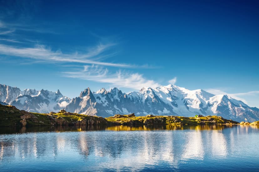
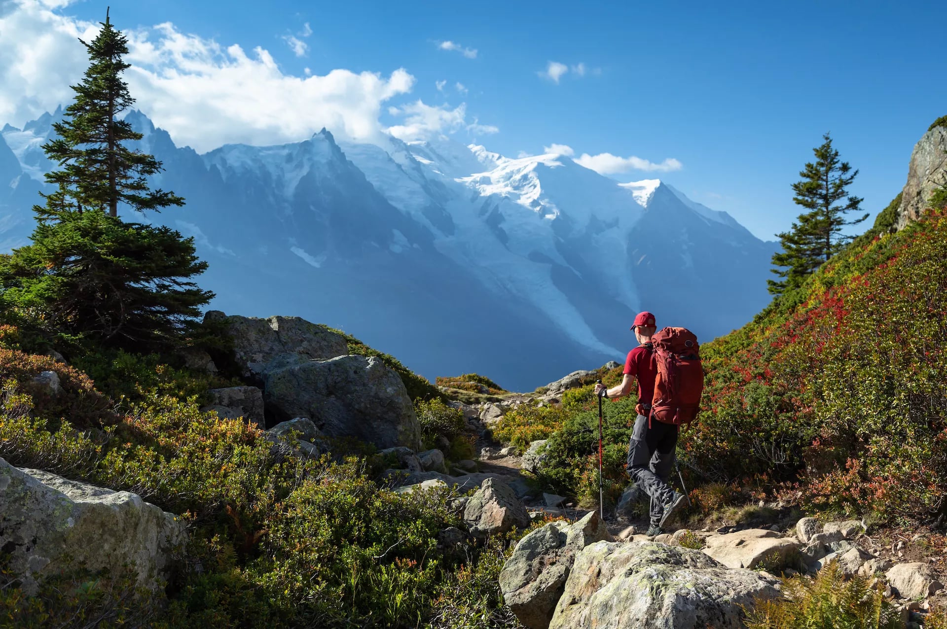
The Haute Route opens with a statement. The climb from Chamonix to Lac Blanc at 2,352 m delivers a full-frame panorama of the Mont Blanc massif reflected in glacial water — one of the most photographed viewpoints in the Alps. The descent to Argentière follows the Aiguilles Rouges ridge with the entire massif at your back.

Day 2 — Argentière to Trient
Col de Balme (2,204 m) marks the France-Switzerland border — a moment worth pausing for. The ascent from Argentière is steady, and the view from the col extends back toward Mont Blanc on one side and into the Swiss Val d'Arpette on the other. The descent to Trient drops through alpine pasture into a quiet Valais village.
Day 3 — Trient to Champex
The Fenêtre d'Arpette variant (2,665 m) is the dramatic choice — a steep, rocky climb rewarded with close views of the Trient Glacier. The alternative through the forest to Champex is gentler and a smart call in poor weather. Either way, you end at Lac de Champex, a calm lake village and one of the route's more restful overnight stops.

Day 4 — Champex to Le Châble
The easiest day on the route and a deliberate recovery stage. The trail follows the Val Ferret downstream through pastoral farmland and forest, with minimal elevation gain. Le Châble sits in the Bagnes valley below Verbier — the last low-altitude night before the route climbs into high terrain for the next several days.
Day 5 — Le Châble to Cabane du Mont Fort
The route climbs through Verbier's ski infrastructure — gondola stations and piste markers feel oddly out of place on a hiking trail — before rising above the resort into open alpine terrain. The Grand Combin massif (4,314 m) reveals itself during the final approach. Cabane du Mont Fort at 2,457 m sets the tone for the high stages ahead.

Day 6 — Cabane du Mont Fort to Cabane de Prafleuri
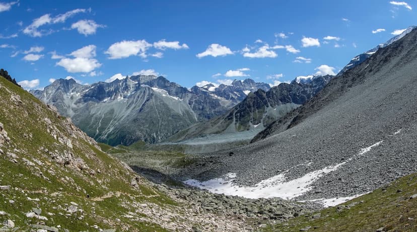
One of the route's hardest and most otherworldly stages. The trail crosses a moonlike plateau near the Grand Désert Glacier, reaching close to 3,000 m. Rocky, exposed, and remote — this is where the Haute Route earns its reputation. The descent to Cabane de Prafleuri at 2,624 m is loose underfoot.
Day 7 — Cabane de Prafleuri to Arolla
The trail follows the shore of Lac des Dix — 5 km of turquoise reservoir backed by the Grande Dixence dam — before reaching the stage's defining decision: two routes descend to the valley below:
Option 1 is the Pas de Chèvres (2,855 m) — fixed metal ladders down steep rock, exposed and technically memorable.
Option 2 is the Col de Riedmatten (2,919 m) — higher but without ladders, a steep scree descent instead. Both converge below and lead into Arolla, which feels like a return to civilisation after three days of high terrain.

Day 8 — Arolla to La Sage
A shorter, gentler stage through the traditional Valais villages of the Val d'Hérens. Stone chalets, terraced vineyards, and a pace that allows for long lunches. The terrain is less dramatic than the days before and after — deliberately so. This is the route's built-in recovery day and a good opportunity to take stock of legs and feet.
Day 9 — La Sage to Cabane de Moiry
The climb over Col du Tsaté (2,868 m) is long and sustained, but the payoff is the approach to Cabane de Moiry — perched at 2,825 m directly above the Moiry Glacier. The final hour follows the glacier's moraine with ice and crevasses visible below. This is one of the most visually striking hut arrivals on the entire route.

Day 10 — Cabane de Moiry to Zinal
The morning descent from the hut drops to the shore of Lac de Moiry — a turquoise reservoir ringed by glacial moraine — before the trail traverses above the lake and climbs to Col de Sorebois (2,896 m). The col is the stage's reward: a wide panorama over the Val d'Anniviers opens up, with the Zinal 4,000ers — Dent Blanche, Weisshorn, Ober Gabelhorn, and Pointe de Zinal — visible in a single sweep ahead.
The long descent passes ski infrastructure before dropping through alpine meadow and larch forest into Zinal, a small, quiet village and a good resupply point before the route's final chapter.
Day 11 — Zinal to Gruben
Forcletta Pass (2,874 m) marks the transition from French-speaking to German-speaking Switzerland — audible immediately on the far side where greetings shift from "bonjour" to "guten Tag." The climb is steep on both sides. Gruben, in the Turtmanntal, is tiny and remote — one of the quietest overnight stops on the route.
Day 12 — Gruben to St. Niklaus
The Augstbordpass (2,894 m) is the last major pass before the Europaweg. The descent into St. Niklaus drops over 1,500 m into the Mattertal — a long, knee-testing afternoon. St. Niklaus is a valley town with full services, and the first place in days where the Matterhorn begins to feel close.

Day 13 — St. Niklaus to Europahütte
The Europaweg begins — a high balcony trail above the Matter valley with continuous views of the Weisshorn massif on the right. The climb from St. Niklaus gains over 1,600 m to reach Europahütte at 2,220 m. This is one of the most physically demanding days on the route, but the hut terrace at sunset — Weisshorn in alpenglow — justifies every metre.
Day 14 — Europahütte to Zermatt
The final stage crosses the Charles Kuonen Suspension Bridge — 494 m long, 85 m above the valley — before a long, gradual descent into Zermatt. The Matterhorn grows larger with every kilometre. Arriving on foot after 14 days of crossing the western Alps is the kind of ending that doesn't need embellishment.
Several stages offer notable alternatives: the Hotel Weisshorn detour on Day 11 adds a night at a 19th-century mountain hotel above Zinal, accessible via Meidpass, and is worth the extra day for those with time. Days 1 and 3 also have gentler alternatives in bad weather.

Days 13 and 14 follow the Europaweg trail — a high-level route with a dedicated trail organisation and detailed stage information available on their official site.
Route Highlights
The Walkers Haute Route passes through some of the most extraordinary mountain scenery in Europe. These five highlights define the experience — each one a reason in itself to make the journey.
Difficulty — What the Ratings Actually Mean
The Walker's Haute Route difficulty is rated 4/5 Technical and 5/5 Fitness — the hardest of the major Swiss and Alpine long-distance hikes. Here is what those numbers mean in practice.
Technical Difficulty Breakdown
The route is a hike, not a climb, but terrain variety is considerable:
Hardpack mountain paths — the majority of the trail; some sections exposed with steel cable assists for balance
Rocky boulder terrain — common on glacial moraines and approaches to the higher passes; the primary ankle-roll risk, especially when legs are tired late in the day
Gravel roads — ski area infrastructure sections, notably above Verbier
Valley asphalt — brief but present on every descent into overnight villages
Stream crossings — some bridged, some require stepping stones and careful footwork
Iron ladders (one section) — the Pas de Chèvres descent above Arolla; fixed and maintained, but essentially mandatory; those with severe vertigo should research this carefully before committing

Fitness Level Breakdown
The daily averages understate the challenge. The route has almost no genuine rest days built in, and the cumulative fatigue across 14 consecutive stages is what most hikers underestimate. A hard day on Day 9 follows a hard day on Day 5 and another on Day 3.
How it compares: More technically demanding and physically harder than the Tour du Mont Blanc (3/5 technical, 4/5 fitness) and the Via Alpina (3/5 technical, 5/5 fitness). The Haute Route sits at the top of the accessible self-guided long-distance hierarchy.
Fitness benchmark: comfortable hiking 18+ km with 1,000 m of ascent repeated over several consecutive days, not just occasionally.
For a detailed guide to what to pack and how to prepare your body specifically for this terrain, see our complete Haute Route packing list.

Full Route vs West vs East — Which Version Is Right for You?
The Walker's Haute Route can be hiked as a single 14-day journey or in either of its two 7-day halves, which split naturally at Arolla — the Valais village that sits exactly at the route's midpoint. Here is how to think about the choice.
Full Route | West Half | East Half | |
Duration | 14 days / 13 nights | 7 days / 6 nights | 7 days / 6 nights |
Route | Chamonix → Zermatt | Chamonix → Arolla | Arolla → Zermatt |
Technical | 4/5 | 4/5 | 3/5 |
Fitness | 5/5 | 4/5 | 4/5 |
Countries | France + Switzerland | France + Switzerland | Switzerland only |
Hut nights | ~6–7 | 2 | 3 |
Price from | €2,995 | €1,495 | €1,945 |
Luggage transfer | Included | Optional extra | Included |
Defining highlights | Complete narrative arc; both massifs | Mont Blanc; Lac Blanc; Pas de Chèvres | Moiry Glacier; Europaweg; Matterhorn |
The West (Chamonix → Arolla) is technically harder (4/5 vs 3/5) due to more exposed passes, more hut-to-hut terrain, and the ladder section at Pas de Chèvres. It includes the route's two opening stages in France, the first appearance of Grand Combin, and the dramatic mid-route climax above Lac des Dix.
The East (Arolla → Zermatt) is slightly less technical but still demands full fitness. It is entirely in Switzerland, more valley-serviced, and ends with the Europaweg and Matterhorn finish. Three hut nights (versus two in the West) give it a slightly higher starting price — huts cost more per night than valley hotels. It is the better choice for those who want the Swiss Alps and Matterhorn without the French stages.
The Full Route is the only version that gives you the complete experience — the full arc from Mont Blanc to Matterhorn, the cultural shift from French to German Switzerland, and the sense of having walked a true traverse rather than a section.
If you have the time and fitness: it is not two separate weeks stitched together; it is something more than the sum of its halves.

Understanding the full costs involved in each version — including accommodation, transfers, and optional extras — is worth working through before committing. Our detailed guide to budgeting for your Haute Route.
When to Hike the Haute Route
The standard hiking season is mid-July to end of September. Conditions vary significantly by year — a heavy winter can keep snow on the highest passes well into July — so checking current conditions before departure matters as much as picking the right month.
For the full month-by-month breakdown of what conditions to expect on each stage, see our dedicated Haute Route weather guide.
Month | Conditions | Verdict |
Late June | Snow likely on Fenêtre d'Arpette, Pas de Chèvres, and Col du Tsate; wet lower sections | Not recommended without snow travel experience |
Early–Mid July | Season opens in normal snow years from mid-month; some pass patches remain | Good — quieter trail; some flexibility needed on higher sections |
August | Peak season; warmest temperatures (25–30°C possible above 2,000 m); afternoon storms | Best infrastructure, worst crowds; start passes before noon; book 8–10 weeks ahead |
September | Most stable weather; crisp mornings; trail quieter | Best overall conditions; preferred by experienced hikers; huts begin closing final week |
October | Huts closed; rain and first heavy snow likely | Not recommended for the full route |
September is particularly special on the Haute Route — our autumn hiking guide explains why experienced hikers prefer it over peak summer.
On August storms: the afternoon thunderstorm pattern in high summer is not occasional — it is routine. The strategy is consistent: be over or below any exposed high pass before noon, and plan each stage's high point for the morning. Temperatures can drop 15–20°C within a severe storm even in August, and lightning on a ridge is a genuine risk. Hut guardians give good daily weather briefings — use them.

Useful Weather Forecasts:
MeteoSwiss — Switzerland’s official forecast source, ideal for Zermatt/Valais and Swiss-alps weather warnings along the route.
Météo-France (Météo Montagne – Chamonix) — The go-to mountain bulletin for the Chamonix/Mont Blanc end, with terrain-aware alpine forecasts (and winter mountain risk info).
Meteoblue — Strong for hiking decisions thanks to detailed hour-by-hour trends, radar/satellite, and forecast uncertainty (“reliability”) signals for both Chamonix and Zermatt.
For a month-by-month look at exactly what to expect on the trail, including the optimal timing windows within each season, see our monthly weather guide to the best time to hike the Haute Route.

Accommodation on the Haute Route
For a first-hand account of what staying in these huts is actually like — the communal dorms, set dinner times, and cash-only payments — read our guide to huts on the Haute Route.
The Walker's Haute Route uses three distinct accommodation types, each with a different character and price point. Understanding the difference before you go shapes your experience significantly.
What to Eat on the Route?
Swiss hut cuisine is built around three dishes you'll encounter repeatedly — and should try at least once each:
Hut Etiquette
Swiss mountain huts run on shared routines, and knowing them makes for a smoother stay.
Dinner is served at a fixed time — typically 6:00 or 6:30 PM — and you sit where assigned, not where you choose.
Quiet hours begin at 10 PM and are taken seriously; dormitories of 10–40 people only work if everyone respects them. Remove boots at the entrance and switch to hut slippers (most huts provide them).
Sleeping liners are mandatory — arrive without one and some huts will charge you for a rental. Showers, where they exist, are coin-operated and brief. Pack out your own rubbish.
Important note: if you're leaving early, pack your bag the night before — a 5:30 AM headlamp rummage through a shared dormitory wins no friends. Respect fellow travellers!
Booking strategy
For July and August, Cabane du Mont Fort and Europahütte in particular should be booked 8–10 weeks ahead minimum. Both are bottlenecks: they sit at mandatory overnight points with no alternative within reasonable distance. September allows more flexibility, but popular huts still fill.

Water
Water is rarely a concern on the Haute Route. Most stages begin or end in a valley town with fountains, hotels, and restaurants where you can fill up before climbing.
Between valleys, streams are plentiful at altitude — a portable filter is the most practical solution for drinking on the go.
Below cattle pastures, filter before drinking. Most huts also sell bottled water if needed. The route is well-serviced enough that carrying more than 1–1.5 litres at a time is seldom necessary.
Getting to Chamonix
Leaving Zermatt
Zermatt is a car-free village. Departure is via the Matterhorn Gotthard Bahn railway to Visp, with onward connections to Geneva (2.5 hours), Zurich (3.5 hours), and international rail routes. The journey out is itself scenic — worth doing in daylight.
Full transport options, including seasonal timetables, are available on the official Chamonix tourism website. Private airport transfers to Chamonix can be arranged when booking a tour with us.

Other Transportation Resources
SBB (Swiss Federal Railways) — Best tool for Zermatt → Visp → onward (Geneva/Zurich) train times, disruption notes, and ticket purchase across Switzerland
Mont-Blanc Express — The key schedule resource for the Martigny ↔ Chamonix valley rail line, useful when routing via Swiss trains into the Chamonix valley
Luggage transfer
An optional extra on all of our Haute Routes. On all organised tours, bags move between accommodations daily while you carry only a daypack. Pack weight target: under 8–10 kg in your daypack.
Training & What to Pack
Before you start training, make sure your budget is sorted — our Haute Route cost breakdown covers everything from hut fees to transport for the 2026 season.
Training
The Walkers Haute Route difficulty rewards preparation more than almost any other trail. The hikers who suffer least are not the fittest in isolation — they are the ones who trained specifically for consecutive days of mountain effort.
Fitness benchmark: Before departure, you should be comfortable hiking 18+ km with 1,000 m of gain, and able to repeat that on back-to-back days without significant fatigue. The cumulative effect of 14 consecutive days is what breaks hikers who came fit but untrained for multi-day repetition. Build towards two consecutive hiking days in the weeks before you leave — even two moderate days of 15 km each teaches the body more than a single 30 km outing.
Footwear: On the haute trail, hiking boots are preferred over trail runners for most hikers — the rocky terrain, scree descents, and ladder sections reward ankle support. Break footwear over at least 3–4 hikes before departure. Blisters on day two are almost always a preparation failure, not a kit failure.

Tilen's Packing List
Core gear
Hiking boots (strongly recommended over shoes for this terrain)
25–40 litre daypack
Trekking poles (essential on rocky descents and ladder approaches)
Clothing
Base layer (merino wool recommended for multi-day odour control)
Sports T-shirt
Mid-layer fleece
Hardshell waterproof jacket (also windproof)
Waterproof trousers
Hiking shorts + long pants
Down jacket (essential, even in August — temperatures drop dramatically in storms)
Evening clothes for huts and hotels
Warm hat, sun cap, lightweight gloves
Hiking socks — 3–4 pairs minimum
Essentials
Sunglasses and high-SPF sunscreen (UV intensity above 2,000 m is significant)
Water bottle + portable filter
Blister plasters and small first aid kit
Sleeping liner (mandatory for hut stays)
Headlamp (early morning starts common)
ID or passport (French-Swiss border crossing on Day 2)
Cash in both EUR (France, Days 1–2) and CHF (Switzerland) — many huts are cash-only
Snacks for on-trail energy
Haute Route Q&A — From Someone Who's Hiked It
We asked Tilen — who hiked the full Walker's Haute Route in August 2024 — the questions hikers ask most, plus a few things only someone who's been on the trail would think to mention.

Q: How long is the Haute Route?
Tilen: "We took 14 days in total, including an extra night at Hotel Weisshorn — which I'd strongly recommend adding. The full route is approximately 200 km across 14 stages with around 15,000 m of cumulative elevation gain. Most hikers should plan for 14 days of hiking plus one or two buffer days for weather or recovery, so 15–16 days total."
Q: Is the Walker's Haute Route harder than the Tour du Mont Blanc?
Tilen: "Yes, significantly. The TMB is demanding, but the Haute Route sits higher on average, has rockier and more exposed terrain, includes the Pas de Chèvres ladder section, and offers fewer easy escape options if something goes wrong. The TMB circles one massif — the Haute Route traverses an entire region. You don't just see Mont Blanc; you start there and finish in Zermatt with the Matterhorn. That variety is what makes it more appealing, but also more demanding."
For a detailed side-by-side comparison, see our Haute Route vs TMB guide.

Q: Do I need mountaineering experience?
Tilen: "No. It's a trail throughout — no ropes, crampons, or technical equipment required. But I wouldn't recommend it as a first multi-day hike. Even though it's not highly technical, it's physically demanding and requires comfort with long days in the mountains, changing weather, and exposure. Some sections include ladders and cables. It's better suited for hikers who already have multi-day experience."
Q: How far in advance should I book?

Tilen: "Book early. Because we booked late, one hut was closed for renovation and we couldn't secure all accommodations as planned — it forced us to hike a longer stretch than intended, which contributed to my injury. For August, 8–10 weeks minimum. Cabane du Mont Fort and Europahütte fill extremely early and have no practical alternatives nearby. On a self-guided tour, all of this is handled for you before you arrive."
Q: What surprised you most about the trail?
Tilen: "Two things. First, the hut dining culture — fixed dinner times, assigned seating, communal atmosphere. It creates a much stronger social experience than I expected. Second, how quickly small physical issues escalate over consecutive days. I strained my Achilles on one stage and got sunburnt on the same day because of bad sunscreen. Shortly after, I got sick. Over many consecutive days, your body is under constant strain, and when something goes wrong, it compounds fast. Patience and rest are your best tools."
Q: Which stretch would you recommend if someone only has one week?
Tilen: "If I had to choose purely on scenery and mountain atmosphere, I'd pick the middle section — starting around Verbier and finishing in Zinal. But splitting the route always removes part of its core appeal. You either miss Mont Blanc and Chamonix or the finish in Zermatt with the Matterhorn. For a less experienced hiker, I wouldn't recommend the Haute Route at all as a first multi-day hike — start with something like the Via Alpina Bear Trek instead."
For the full breakdown of the Via Alpina, see our Via Alpina ultimate guide.
Q: Any concrete hut or viewpoint recommendations?
Tilen: "Cabane de Moiry is a must-stay — it sits right next to the glacier, and the setting is spectacular. Book Europahütte in advance as well; both offer not just great locations but memorable mountain atmosphere. For viewpoints, the pass above Lac de Moiry looking down toward the Zinal valley and surrounding high peaks is breathtaking.

Cabane de Moiry is a must-visit for a comfortable overnight stay and a hearty meal on the Haute Route
And the panorama when hiking from Zinal toward Hotel Weisshorn — when you turn around, you see the peaks of the Val d'Anniviers, including Dent Blanche, Weisshorn, and Pointe de Zinal. In good weather, you can even spot the Matterhorn in the distance, though most people don't recognise it at first."
See our Haute Route accommodation guide for other recommendations.
Q: What would you do differently?
Tilen: "Three things. First, train more specifically with a heavier backpack — I was used to long mountain days but not properly conditioned for carrying weight over consecutive days. Second, book accommodations earlier to avoid logistical compromises. Third, invest in proper high-SPF sunscreen. At altitude, UV intensity is no joke. Those are all preparation issues, not trail issues — the route itself is extraordinary."
Plan Your Hike With Us
Three formats. One trail. The question is how much of it, and when.

The full Walker's Haute Route — 14 days, Chamonix to Zermatt, Mont Blanc to Matterhorn — is one of the great experiences in European hiking. The West gives you the French Alps, the first glaciers, and the dramatic mid-route high point at Pas de Chèvres. The East takes you through the Swiss Alps, above Moiry Glacier, across the Charles Kuonen Bridge, and into Zermatt.
All three versions are fully self-guided: accommodations booked, GPS routes delivered before departure, and our team available throughout. You bring the preparation; we handle the logistics.
Ready to start planning? Browse all available Haute Route tours in our offering or send us your questions and preferred dates via our inquiry form and we'll come back to you within a few hours.


Hassle-Free
We handle itineraries, accommodations, and anything else you prefer not to deal with, so you can enjoy a carefree hike.

Book with confidence
We are a financially protected company, fully bonded and insured, keeping your money safe and allowing you to travel with confidence.

Tried & Tested Adventures
Only the best hut to hut hikes of Switzerland, cherry-picked by our local team with an in-depth knowledge of the region.

Unbeatable support
Our 24/7 customer support is where we show our passion, bringing you a better experience by making your well-being our number one priority.